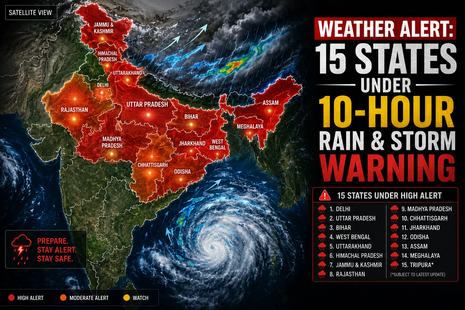
The weather patterns across India are undergoing a massive shift. Following its timely onset over the Kerala coast, the Southwest Monsoon is steadily advancing further into the Indian subcontinent. Amidst this transition, the India Meteorological Department (IMD) has issued an urgent weather warning today, June 18, 2026, predicting severe thunderstorms and heavy downpours across 15 states within the next 10 hours.
Meteorologists have warned that these severe weather conditions will be accompanied by high-velocity squalls, with wind speeds potentially clocking up to 65 km/h. The public has been advised to exercise extreme caution and minimize outdoor movement during peak storm hours.
Weather Update: IMD Issues High Alert Across 15 States
According to the latest meteorological data, a combination of an active Western Disturbance and advancing monsoonal winds is triggering widespread instability across Northern, Eastern, and Central India. The IMD has highlighted specific zones that fall directly under this high-alert window.
Key Affected Regions and States:
- Northern India: National Capital Region (Delhi-NCR), Uttar Pradesh, Punjab, and Haryana.
- Himalayan Region: Jammu & Kashmir, Himachal Pradesh, and Uttarakhand.
- Eastern & Central India: Bihar, Jharkhand, West Bengal, Madhya Pradesh, and Chhattisgarh.
- Other Impacted Areas: Rajasthan and pockets of Northeastern states (Assam and Meghalaya).
Weather Update: Delhi-NCR to Witness Sudden Weather Shift
Residents of Delhi and its neighboring areas (including Noida, Ghaziabad, Gurugram, and Faridabad) can finally expect an end to the ongoing spell of intense humidity and heatwave conditions.
The IMD has placed the national capital under a rain and dust-storm alert. The collision of wind systems is expected to bring lightning, moderate rainfall, and gusty winds. This activity will significantly drag down both maximum and minimum temperatures, offering much-needed respite to the region.
Monsoon Advance and Alerts in Uttar Pradesh and Bihar
The dual impact of pre-monsoon turbulence and the advancing monsoon front is triggering intense weather activity across the gangetic plains of Uttar Pradesh and Bihar.
- Uttar Pradesh: Both eastern and western districts of the state are on a high yellow alert for thundersqualls reaching up to 65 km/h. Local authorities have warned of potential damage to weak structures and localized power outages due to uprooted poles.
- Bihar: Heavy rain accompanied by continuous cloud-to-ground lightning is predicted for several districts. Farmers and rural laborers have been strictly advised to avoid open fields or seeking shelter under trees during the core alert window.
Himalayan States Face Hailstorms and Landslide Risks
The hilly terrains of Himachal Pradesh, Uttarakhand, and Jammu & Kashmir remain the most vulnerable zones under this 10-hour alert window due to their geographical layout.
| State | Primary Weather Warning | Expected Wind Speeds |
| Himachal Pradesh | Heavy downpours, severe thunderstorms, and isolated hailstorms | 40–50 km/h (Gusts up to 60 km/h) |
| Uttarakhand | Intense cloudburst-like spells and severe lightning | 50–60 km/h |
| Jammu & Kashmir | Higher altitude snow/rain mix with severe hail risks | 40–50 km/h |
Tourists and commuters traveling through these mountainous routes are advised to closely monitor local administration updates, as sudden cloudbursts can trigger flash floods and sudden landslides.
Safety Guidelines: How to Protect Yourself During Severe Winds
IMD Critical Advisory: When wind speeds breach the 60 km/h mark, loose structures, unanchored signboards, and old trees pose a fatal risk.
To ensure safety during this active weather window, strictly adhere to the following safety protocols:
1.Stay Indoors:Seek immediate shelter.
As soon as dark clouds gather or wind speeds pick up, move into a structurally sound, permanent concrete building. Avoid temporary tin-shaded or thatched roofs.
2.Unplug Electronic Appliances:Mitigate lightning hazards.
Severe thunderstorms are highly prone to causing voltage surges. Disconnect expensive household electronics like TVs, refrigerators, and computers from power sockets.
3.Park Smartly and Safely:Prevent vehicle damage.
Do not park cars or two-wheelers beneath tall trees, weak brick walls, or overhead power lines. Falling debris is the leading cause of vehicle damage during squalls.
4.Pull Over if Driving:Handle low visibility.
If you are caught on a highway or road during a sudden dust storm or blinding rain, safely pull over to the side, turn on your hazard lights, and wait for visibility to clear.
Conclusion
The massive weather shift taking place on June 18, 2026, is a direct result of monsoonal progression intersecting with regional atmospheric disturbances. While the incoming rain will successfully break the intense summer heat cycle, the accompanying 65 km/h winds and lightning strikes introduce real logistical hazards. Treat the IMD alerts with priority, stay updated through verified channels, and prioritize personal safety.
Frequently Asked Questions (FAQs)
Q1. Which 15 states are on maximum alert today (June 18)?
The high-priority alert covers Delhi, Uttar Pradesh, Bihar, Punjab, Haryana, Madhya Pradesh, Chhattisgarh, Jharkhand, West Bengal, Rajasthan, Uttarakhand, Himachal Pradesh, Jammu & Kashmir, Assam, and Meghalaya.
Q2. What is the maximum expected wind speed during this storm?
According to the IMD, core plains and storm zones could experience sustained wind gusts ranging between 65 km/h and 80 km/h during the peak of the thunderstorm.
Q3. Has the Southwest Monsoon officially hit Delhi?
No. The current rain spells over Delhi-NCR are attributed to pre-monsoon activities and a Western Disturbance. The official arrival of the monsoon in the national capital is expected around its normal timeline toward the end of June.
Q4. What are the primary risks associated with this weather alert?
The primary dangers include lightning strikes, structural damage to weak or temporary properties, uprooted trees blocking highways, and flash waterlogging in low-lying urban areas.
For more information, follow Shabdsanchi‘s social media pages today and stay updated.
- Facebook: shabdsanchi
- Instagram: shabdsanchiofficial
- YouTube: @shabd_sanchi
- Twitter: shabdsanchi